
“An adventure is a situation where the outcome is not entirely within your control. It is up to fate, in other words” – Henry Youngman
 Triglav, at 2864m, is the highest mountain in Slovenia and the highest peak in the Julian Alps. The mountain is the Slovene National symbol and is the centrepiece of the Triglav National Park, Slovenia’s only national park.
With a resume like that and the fact it looked just so inviting in so many photos a plan had to be hatched to go and climb it!
While in India in 2018 I’d met two fellow mountain enthusiasts (enter Ben and Matt), we’d all climbed to the top of Stok Kangri together in Ladakh that year and had all shown an interest in having another adventure together. Fast forward to September 2019 and here we all were in Slovenia!
Plan A
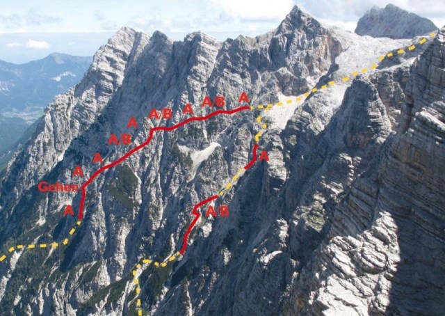
The plan on paper was pretty simple, we had selected a medium difficulty Via Ferrata route on the northern side of Triglav named the Tominskova Pot which ascended to a mountain hut (the Triglavski dom na Kredarici). The next morning we would leave the hut early for a summit attempt before an afternoon descent all the way back down to the valley floor. Not overly ambitious if the weather played ball, which having strategically picked the most stable time of year (September), all looked infinitely achievable.
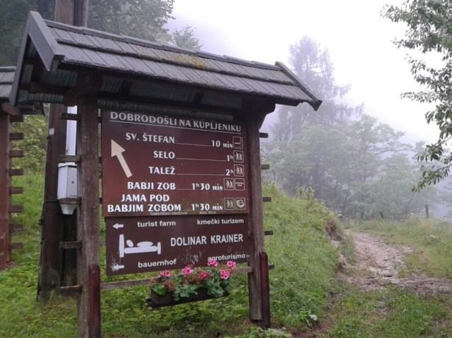
We left on the morning of Friday the 6th September flying out to Ljubljana where we picked up a hire car and then drove on up to Bled where we had picked a working farm stay in Kupljenik as our base while in the foothills of the Triglavski National Park.
However, from the moment we had touched down in Slovenia the weather had taken a turn for the worse. We knew the weather was looking a trifle bad from the weather reports but this rain was almost biblical in its ferocity and only Noah would have felt comfortable venturing out into it.
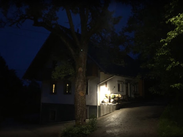
As we arrived at our lodgings conditions had not improved. The usually beautiful and picturesque farmstead of Dolinar Kraener was shrouded in thick mist, so much so that we almost missed it completely while driving up the steep and winding country lane out of Bled.
 Eventually having spotted the farm we knocked on the wooden door of the chalet building where the owner greeted us with incredulous surprise that we had made it this far, before then proceeding to tell us with great foreboding that we must be mad to want to still try and climb Triglav in these conditions which were now due to set in for the entire weekend.
In true British fashion we dismissed their warnings. A chorus of derision and disbelief ensued from the owner and her husband who had now also made an appearance ending abruptly in something along the lines of ‘the British were all completely mad!‘ We resolved to press on as before with our plan.
 After a meal, a beer and much conversation around plans down in a bar in Bled we hunkered down for the night back up at the farm. We packed our gear into our rucksacks in anticipation of the next days climb and tried to get some sleep before tomorrow’s big adventure.
We awoke on Saturday to thick clag and mist accompanied by the constant drizzle of incessant rain! Visibility was down to a few metres and all thoughts of climbing a 2-3B graded VF route seemed dashed. I readily concede I’m touched with a modicum of British madness myself but I’m not suicidal and neither were my colleagues, a plan B clearly had be thought up and quickly!
Enter Plan B
We really did not have a proper plan B so we hatched one quickly. Instead of our now overly ambitious plan to summit via the North Face of Triglav from the Vrata valley using the Tominšek Route we set our sights somewhat lower and arrived upon the Pokljuka High Plateau Route. This is the easy option on the mountain but given the adverse weather the next to zero visibility and a forecast of thunderstorms and possibly even snow we thought it a prudent decision
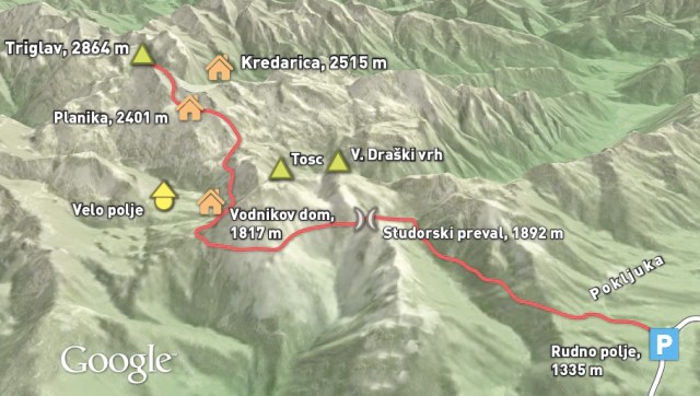
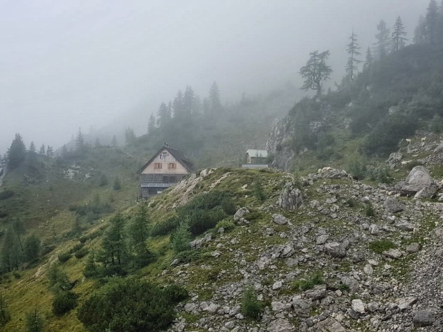
We’d pre booked back in the UK into the Kredarici Mountain hut based on a northern ascent but now getting to it would just add extra mileage to the venture so we blew that idea out of the water and decided to make for the nearer Dom Planika hut instead. We had no reservation but banked on so few people being mad enough to be out in these conditions that there would be plenty of dorm space. If when we arrived there we felt conditions had improved then we would attempt to make a summit bid there and then.
Most people trek to the hut, stay overnight then summit on day two. We did not have this luxury given that the weather forecast was due to worsen still further on the Sunday wiping out any possibility of a summit. It was just a whisper but it was rumoured that there could possibly be a two hour weather window around midday on the Saturday and we were aiming for that, not ideal, but our only real chance of-gleaning any success from the trip.
So with a new plan and set of hastily rearranged trailhead co-ordinates tapped into the car Sat Nav at 6am in the morning we set off into the dark to find Rudno Polje the 1347m starting point of our new route.
The torrential rain continued and after several attempts at finding a way to the start point along a road that hadn’t become blocked or flooded we eventually rolled up at the Slovenian Army Barracks at Rudno Polje. We parked, kitted up and left immediately starting up a forest trail in the misty first light of dawn.
 The route was an easy follow through dense forest followed by low alpine meadows. We could hear cow bells jangling in the distance and the noise of water tumbling over rocky beds but we couldn’t see the beasts nor the tumbling streams as all were enveloped in murky mountain mists.
Along the trail we seemed to inch past many precipitous edges with drop offs to the depths below but could never gauge the real danger due to the appalling visibility. After four or more rain soaked hours of trekking and misery we finally sighted the elusive Dom Planika Hut when miraculously emerged from the swirling mist and fog.
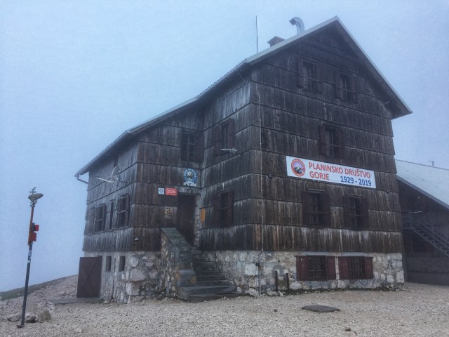 We entered the warm and dry hut asking the warden if we could (a) stay the night, evidently 160 other people had cancelled their bookings due to the weather and (b) if we could dump our heavy gear in the boot room just in case we thought we could make a summit bid. With a yes to both we hastily dumped all unnecessary gear out of our heavy rucksacks took a look outside and decided to harness ourselves up for a possible summit push.
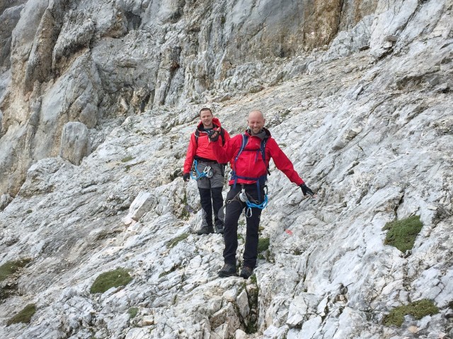
The route from the Planika hut is considered the easier summit ridge route but in these wet slippery conditions and with impending thunderstorms due we were just looking for a quick smash and grab, literally up and down. We were all desperate to avoid being harnessed onto the metal cabling and pins that run along the upper end of the route when the predicted storms arrived.
So with harnesses on and more or less everything else dumped we emerged from the mountain hut to take a serious look at the route ahead of us and to see if realistically we thought we could get up and down in time before the afternoon storm.
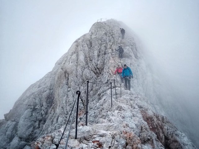
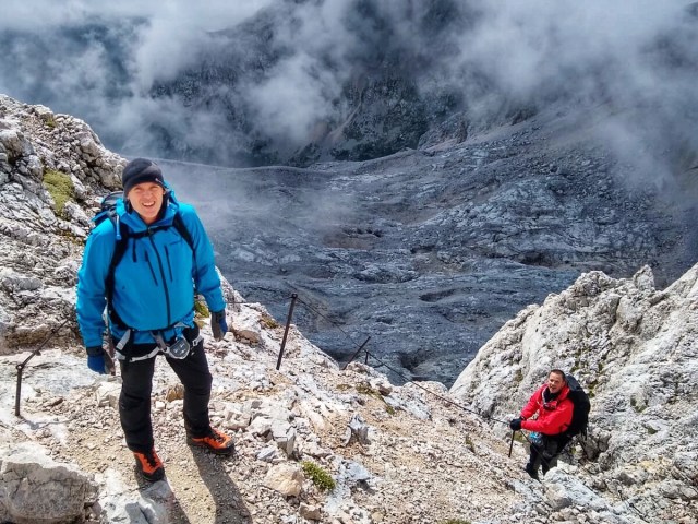 Miraculously the skies began to clear! It was unbelievable! We did not need a second invite. We started to ascend the rock face. The route to the ridge was fairly easy as we followed the red and white path symbols upwards. A few protected areas at the harder pitches of the route added some interest.
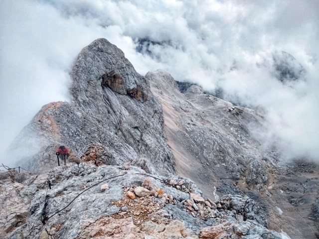
 We arrived at the famous Ridgeline leading first to Mali (little) Triglav and further beyond to Triglav herself. The wind buffeted us for the first time now, the rocks were polished and slippery and we gingerly made our way along the ridge. But the rain abated and for the first time I thought to myself that possibly just possibly the summit might be within our grasp!
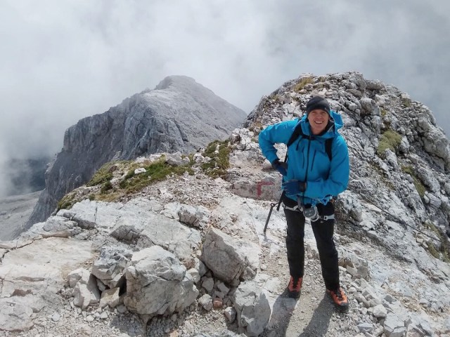
The ridge seemed to go on forever in a series of ascents and descents always getting gradually narrower. We passed only four other lunatics along the ridge the whole time. I had one eye on my foot placement and one eye on the weather the entire way.
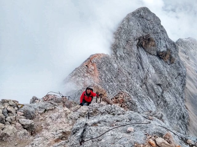 I confess I did not clip into the fixed cables at any point. A dangerous decision in the conditions but I was more concerned on timings with the weather window than my ability to climb. Both Ben and Matt felt the same way and we all made the decision to ditch using the lanyards. This gained us valuable speed but at the risk of a slip or at worse a possible fall.
Then the clouds burst open and the elusive yet familiar sight of the Alujez Shelter on the summit came into view. A few more careful strides and we would all be on the summit of the highest mountain in Slovenia.
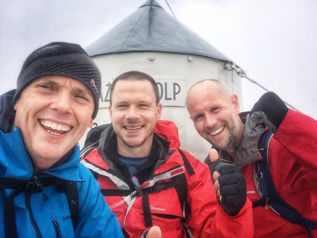 We’d made it! Elated we rested for 5-10 minutes before hitching the rucksacks up onto our backs and beating a hasty retreat down. But the weather Gods had not finished with us just yet!
Within minutes of starting our descent sleet began to fall. The wind picked up and the rocks became super slippery. It was now a battle to get safely down. The balance of expediency and safety had to be just right. Conditions worsened and we had a couple of slips and slides which alerted our senses.
 We emerged from the gloom of the encircling storm clouds to pop out just above the Dom Planika Hut, a very welcome sight. I let out a shriek that echoed around the mountains. I’m sure Ben and Matt felt the same kind of relief. We waddled, limped and dragged ourselves back over the scree path to the hut. It had been an 8 hour marathon of a day and a herculean push for the summit and then back down to the hut all in one day.
 We sat knackered in the hut ordered some cold beers and felt lucky to have had a chance against the odds to get a summit in before collapsing onto an exhausted slumber.
During the night the wind howled, thunder echoed outside and lightning lit up the windows. We knew we had been lucky. When morning came we started to descend in the gloop and rain along the same route we had trekked up the previous day. Later upon our return to civilisation we learnt that the snows had swept in a day after we had been up there and the mountain was now smothered in the white stuff.
We had just made it in the nick of time. Not as originally planned but we had still returned home from the adventure having summited the highest mountain in The Julian Alps and Slovenia and the trip was a great way to sign off the season of 2019.
Check out more photos from my adventures at: https://www.flickr.com/photos/jameshandlon/albums
Download GPX data for the route at:
http://www.shareyouradventure.com/map/81666/jamehand/Triglav-2864m-Julian-Alps-Slovenia-2019
Accommodation:
https://goo.gl/maps/
