The Route: Jebel Toubkal | Distance: 10.6km | Time: 7 Hours Height gain: 1866m | Max Altitude: 3207m | Start: Imlil Village | Finish: Neltner Refuge Map: Orientazion – Toubkal Hiking Map ISBN: 9788493560003 | Date: 07/06/2014
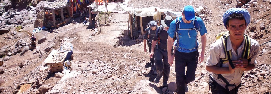
I arrived with my new best friends in the village of Imlil. Imlil is the gateway to the Atlas Mountains and the start point for our trek. From here on in there was only one way and it all led uphill! We all stocked up on water supplies from a small tea shop on the edge of the main street through the village while our newly acquired muleteer loaded up our mule for the journey. Our main holdalls would be carried by mule up to the Neltner Refuge, beyond that point the mule don’t go, so we would be carrying our daysacks from that point on.

I felt a definite pang of sadness engulf me as the poor old mule was loaded higher and higher with our bags and various other equipment but he (or she) seemed to take it all in their stride, such is the life of a mule I guess in Morocco.

With my first world sensibilities eventually pushed to the back of my mind after figuring out that I was actually rather glad that the mule was carrying my gear as opposed to myself in the increasingly stifling heat of the day the merry band of adventurers that I was now part of finally set off on the two day trek to Toubkal National Park. Following a river that climbed gradually out of the valley that would eventually lead to the seasonal village and shrine of Sidi Chamharouch (2310m) we set off at a healthy pace.


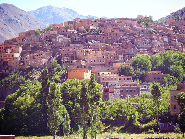
I soon found myself passing by very typical looking Moroccan homes and shops with their wares displayed out front on the dusty roads. We passed children playing in the lanes and fields, donkeys passed us laiden with baskets containing nuts and fruit and soft drinks either going into town or heading like us up to the refuge. We turned several corners and ascended several gentle slopes before we caught our first glimpse of Around. Around is the last of the series of villages that make up the trail head in the Mizan Valley. This amazing village is perched precariously on the slopes of the surrounding hills making picture perfect opportunities for the traveller with a camera.
Departing Around we crossed a dried up river bed at the confluence of two rivers before the path steepened and narrowed as we zig-zagged our way up higher into the hills.

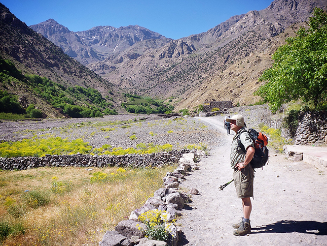
We hoped to reach Sidi Chamharouch by lunchtime so that we could recuperate in some shade and enjoy some much needed food and drink. The path relentlessly weaved it’s way along the eastern slopes of the valley and we marched like lemmings towards our destination.
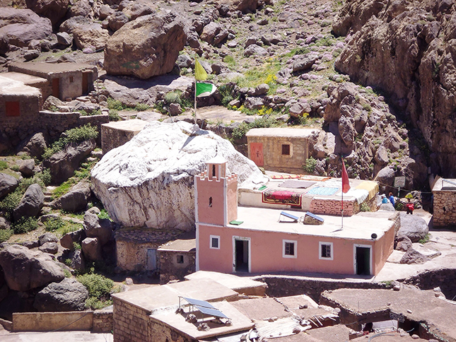
Sidi Chamharouch is a strange and mystical place. It is surrounded by rocky peaks and sits astride a fast flowing river descending the valley. A huge white-painted boulder marks the spot where, legend has it, a holy man lies entombed. As an infidel access to the actual shrine is forbidden but we gained a good view of the inner sanctum from the confines of the small eatery that we stopped for lunch.
As I sat swallowing some freshly squeezed orange juice on an old wooden chair it was surreal to look down and see fresh red blood being washed from the rocks behind the shrine. I was beginning to see why westerners were not given access to the shrine!
Animal sacrifice it still carried out at the shrine on a daily basis with goats and sheep etc being ritually butchered on a flat rocky plateaux behind the shrine. I saw what looked like a goat being dealt with in this manner from my vantage point above the shrine buildings. Not a sight to want to see too often but I was after all in Morocco and I had come to see the world and embrace its diversity warts and all so that was what I was getting.


We left Sidi after an hour or so and our weary legs found it hard to get back into the rhythm of the trek as the heat intensified and the inclines increased. From this point on I really could feel the altitude begin to kick in. The air was thinning and the rays from the sun intensifying as a result our ever increasing height. The surrounding mountain landscape was becoming more lunar like the higher we progressed up the valley as we plodded on and on.
After several intense hours of trekking over rocky paths and fording many mountain streams in the process I began to scan the horizon for the Club Alpin Francais hut which I hoped would not be too far away but it would be a good few hours more before we finally reached the Neltner Refuge.


Then like a mirage the refuge suddenly appeared, almost camouflaged against the rocky backdrop of mountains beyond. A sense of relief and joy gushed over me as I now knew that phase 1 of the adventure had been completed! I had made it to (3207m). I had no ill effects from the altitude and this building that resembled a Berber fortified dwelling would now be my home for the next night. Although I knew the hut is very basic I could not have been happier even if I had racked up outside a five Star hotel.


After my initial happiness at reaching the Neltner Refuge my mood would soon change as I embarked upon one of the most horrendous nights of my life!

The refuge sleeps around 80 people with around 20-30 in a dorm, my dorm was rammed! I had been allocated a small bunk on the bottom level smack bang in the middle of a row of ten. I dropped my pack and sleeping bag off on the stiff mattress bunk before going downstairs for the evening my meal realising that sleep may well be a rare commodity that night.
As 10pm neared and the prospect of a 5am start in the morning was realised we all decided to turn in for the night. WRONG! no one sleeps in the Neltner and I mean no-one! With hikers arriving up until 1am sleep is almost impossible. Headlights flashed in the night, people struggled in and out of bunks and the smell, well the smell is one thing you cannot describe in words!
On top of the impossibility to sleep I had now developed what can only be described as the heebie jeebies! Suddenly I was crippled with anxiety and apprehension of the task I had set myself for the morning. I spent several hours perched on a third world toilet in the basement of this god-forsaken building high up in the freezing and deathly quiet mountains playing mind games with myself.
What if I could not make it to the summit? What if I suffered from altitude sickness above 3200m? What if the others wanted to press on and I couldn’t? Had they not all summited at altitude before, was I not out of my league? After months of training and saving up money to get to Morocco I was in danger of sabotaging my own trip! I lay for hours on a bench downstairs in the foyer of the building unable to get back to my sleeping bag in the dorm almost frozen by fear as the wee hours of the night turned my imaginings into imagined reality!
Jebel Toubkal Route Route Map

The Highs and the Lows of the hike

flickr Pics: https://www.flickr.com/photos/jameshandlon/sets/72157644711701358/
Full mapping of the routes and GPX downloads available from:
http://www.shareyouradventure.com: http://www.shareyouradventure.com/map/51094/jamehand/The-Jebel-Toubkal-Challenge

I love how you described your journey through Imlil Village.
LikeLiked by 1 person