

Well actually from the DMZ to the Delta! As with most things in my life I seem to do them in reverse order. But here we were in north central Vietnam and it seemed rude not to take a look at the famed (or infamous) depending on your viewpoint DMZ.
DMZ refers to the so called demilitarised zone that divided Vietnam at the 17th parallel during the Vietnam War. It is one of the greatest misnomers ever! The DMZ which consists of a 6 mile-wide (10km) strip of land straddling the Ben Hai River actually had more bombs raining down on it than almost anywhere else in the entire country during the war years. A result being a massive minefield of (UXO) or unexploded ordnance that has claimed more than 10,000 lives since the bloody war ended. Our advice was stick to the road while exploring! So I was glad that we were in the safe hands of our guide and driver again from the previous days trip to The Marble Mountains. (to my detriment their names elude me)
We had left a now familiar scene of rain and clouds in Hué early that morning and headed north towards Dong Ha considered by most to be the gateway to the DMZ, we then blazed a trail along Route 9 towards the Truong Son Mountains and the foothills of Laos.

Ultimately we were headed for Khe Sanh the famous US combat base close to the Laos border and the Ho Chi Minh Trail, but along the way we visit a myriad of names and places now sun-ominous with the brutal war of the late 60’s and early 70’s.
We went past Cam Lo a onetime American firebase until we came upon ‘Firebase Fuller’. The firebase is on the summit of a hill 1,785-foot (544m) high. From there the US artillery once hurled shells as far as Khe Sanh a whole 25 miles (40km) away. Farther along we passed Camp Carroll named after a Marine captain killed by friendly fire in 1966 before reaching the now famous ‘Rockpile’.
The Rockpile is a 755-foot (230m) hill off the right side of the road and in 1966 U.S. recon troops set up an observation post on the hill. The post had been abandoned in 1968 but until then it had been used to direct artillery in support of passing ground troops along Route 9. The hill looks and feels every inch the part and you can almost hear and feel the shells crashing around from up high with weary US troops hankering down in the paddy fields and rice plantations in the valley below. Today however, everywhere was silent and an eerily quiet mist shrouding the hill.

Climbing up past some farm villages which are home to a Vietnamese minority tribe called the Bru highlanders we neared Dakrong Bridge. The bridge over the Quang Tri River was a focal point for troop movement during the war which now serves modern trucks from over the borders from both Laos and Burma, a memorial memorizes the fact that the Ho Chi Minh Trail once intersected Route 9 at this point.

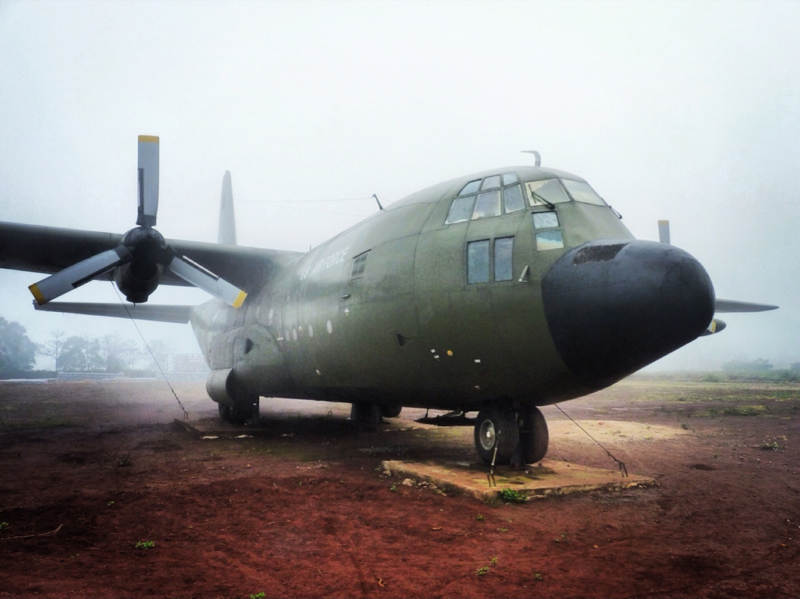
A further 8 miles west and we finally reached the days main objective Khe Sanh. This was the site of the largest U.S. combat base in the DMZ and was a red-hot centre of the war during 1968. In 1967 the NVA massed an army of near 20,000 troops in the surrounding hills diverting American attention from the Viet Cong’s main assault ‘The Tet Offensive’ elsewhere. The yanks dropped a reported 75,000 tons of bombs on the NVA positions killing it is estimated 10,000 Vietnamese while 200 American lives were lost on the base due mainly to incoming mortar fire from the hills around.

Today a sobering museum stands in the middle of the airstrip surrounded by deserted aircraft, helicopters and ordnance, chilling reminders of what once happened at this very spot. Debris was everywhere, you could literally find spent cases lying in the undergrowth and climb in bombed out tanks and the empty husks of vehicles.


As we viewed the trenches and airstrip a wet mist and claggy fog closed in and around us from the surrounding hills creating an unbelievable sense of foreboding and reminding us what a remote, lonely and desolate place this must have once been for many young conscripts fresh off the plane or boat just in from the good old US of A.
Having spent a sobering hour or so at the base it was time to clamber back into our 4WD and head east once more and back the 50 odd miles to the Ben Hai River to see and cross the other famous icon of the war ‘The Hien Luong Bridge’.
The Ben Hai River was once the demarcation between North and South Vietnam along the 17th Parallel a no-man’s land. The Hien Luong Bridge straddles the river and now serves as a memorial to the war. On the north side of the river crossing from the south you can still see the barbed wire and propaganda speakers left over from the war still strewn along the banks of the river, together with the now ubiquitous telegraph pylons that always seem to make an appearance in the american movies of this war and seem so iconic of the conflict as a result.

Looking down as I crossed over the bridge the river below was murky swollen by constant rain which had been an almost constant companion throughout our day, so as it drew to a close I think we were all fairly happy to be heading off to the shelter of some caves, for at least they would be out of the rain even if they may be damp and dark once we were inside.
The Vinh Moc Tunnels system sheltered hundreds of refugees for over six years during the war after the villagers had been displaced due to heavy U.S. bombing in 1967. Families lived on three levels underground in cramped cells gouged out of the rock for many years.
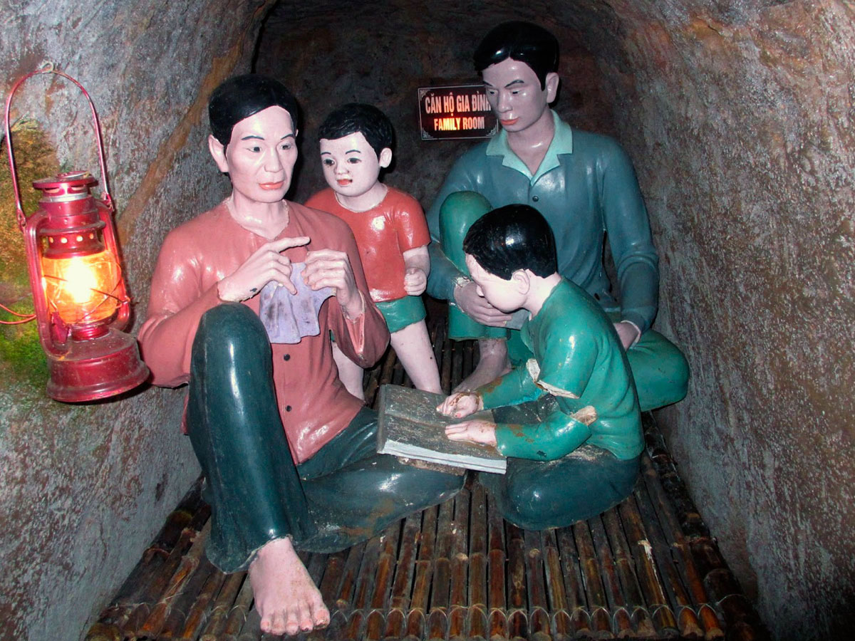
During the height of the war the tunnels were bombarded by 500 rockets a day, at night the tunnel dwellers risked discovery by the U.S. Navy patrols as they ferried supplies to Con Co Island some 17 miles offshore in return for food and ammunition which was then relayed south to help the communist cause.

The tunnels were fascinating to explore and navigate though especially when exiting through the cliff face out of one of the many secret entrances, out and into an overgrown jungle beach, with a clear view of Con Co Island in the distance. I found the tunnels to be compelling and one of the most fascinating places I had so far visited in Vietnam and they certainly made a fitting end to the whole days proceedings.
You can see more photos from my Indochina Adventure on Flickr by clicking on this link: https://www.flickr.com/photos/jameshandlon/sets/72157629031722105/
