The Route: The Northern Gritstone Edges
Distance: 32.00km (20 miles) | Time: 2 Days | Highest Point: 538m/1765 ft
Start: SK173894 | Map: OL1 & OL24 | Date: 11/06/2011 | Finish: SK263737

Sitting at Sheffield Station covered in rotting peat bog with blisters the size of golf balls and not a bone or joint that did not ache I began to fully appreciate the achievement of the last 2 days.
I had finally hiked along the gritstone edges of the Peak District National Park covering over 20 miles of walking over tough terrain in truly atrocious conditions. I had carried a 65 Litre rucksack containing all my equipment including my tent for the night and all my camp gear, food and clothes.
During the trip I ‘d been soaked by incessant sheet rain, bombarded with hail stones, been chased by thunderous storms across the skies, and thawed out by brief periods of sunlight only to then be soaked through again and again and so on and so on. I reminded myself that I had opted for all this misery out of choice many years ago. Five years ago, to be precise, when I had read an article in a hiking magazine about this particular route and been enthralled by what I had read. Back then it had inspired me to get off my arse and start seeking some adventure, but I had never got round to completing the original hike detailed in the article in question. So here I was, sitting, waiting for a train back to London, having finally had a crack at the hike several years later, sitting as I was now covered in mud and slime, the result of more of an adventure than I could have anticipated or imagined.
The plan in itself was simple enough, get to The Peaks by any means, then get to the northern tip of the edges at the top end of The Upper Derwent Valley and then hike all the way south following the edges until they were no more, until they ran out, and finished some 20 miles further south at the tiny peakland village of Baslow.
I had chosen the summer for some supposed good warm weather and picked out North Lees Campsite in the shadow of Stanage Edge as my overnight stop to pitch the tent and camp. As it turned out the British summer and its weather never really happened (surprise, surprise), and as a result the unseasonal weather in its place had turned a fairly simple hike into a mini epic.

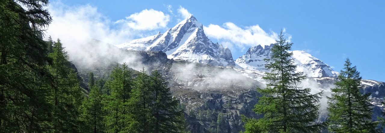
The first day had more or less gone to plan with the hike up from the immense Dam at Ladybower through to the moorland up higher on the edge of Little Howden Moor. The landscape was both beautiful and wild, the weather however had already thrown hailstones at me followed by intense cold sheet rain, but the adventure was still new at this stage and it all added to the spice of things.


The trek up to the cairn at Lost Lad was both enjoyable and scenic, views from the cairn were as ever inspiring. I followed the edge of Derwent for some 2-3 miles stopping for some brief lunch atop Back Tor. Later hiking on towards the distinctive Wheel Stones and swinging a hard left in the direction of Moscar Lodge and the start of the climb up the northern end of Stanage Edge.

At the foot of Stanage the dark storm clouds that had chased me all the way south from Howden finally caught up with me and I was duly drenched! At this stage though nothing could dampen my mood or my resolve and I clambered up through the disused quarry at Stanage’s northern start and enjoyed the views across a rain-soaked but very dramatic Moscar Moor.

With the edges of Derwent and most of Stanage Edge now being ticked off the route with the first day almost under my belt at last I was now looking in good shape to make camp earlier than expected. In fact I made camp around 5.30pm at North Lees, a wonderful little wild natural camping ground run by the park authorities. Although the day had been blighted by rain and then hail with strong chill winds mixed in for good measure I had made good time and all bode well for the morning. I set up my one-man backpacking tent with a smile on my face heartened by the thought of some warm food from my tiny camp stove.

The night though proved to be cold, bitterly cold for this time of year, and I could easily see the moon in the clear night sky through the opening in my tent porch. The clear late evening skies of the previous day had led to a cold moist and dew drenched night. As day two began to dawn I had not managed to catch much sleep, my 3 seasons sleeping bag feeling very inadequate and not totally fit for purpose.

As a result of being awake I broke camp nice and early in the morning and started heading back up through the beautiful woods of the Stanage Plantation behind the campsite and back up onto The Edge.

Day two started very promisingly indeed with relatively clear skies and even some faint sunshine. After thirty minutes or so I started to descend from the southern end of Stanage Edge and began to cross the moors towards the Upper Burbage Bridge. I passed the distinctive Cowper Stone and took in the sweeping moorland vistas at leisure but in an instant the day began to unravel.

Somewhere between the Cowper Stone and the tiny Upper Burbage Bridge I had come across a lamb in distress, the poor thing had fallen into one of the many peat bogs that litter the moor around there and was unable to get out and thus was sinking fast by struggling. With only its head still above the surface of the bog there was nothing for it but to give it my best shot at an attempted rescue. 5-10 minutes of failed bids and now tiring arms left me exhausted and the beast still stuck in the bog. I cursed my urban upbringing and subsequent uselessness in the wild! So with one last resolve and push, getting almost sucked in myself I gave a last-ditch tug and unbelievably even miraculously (with peat bog flying everywhere) the air pocket that was sucking the lamb down suddenly burst and out popped the poor blighter to land neatly on my chest severely winding me in the process.

The lamb then proceeded to use my chest as a mighty springboard and sprung off darting across the moor free again, a black smelly bedraggled mess, but alive and bleating as loud as it could muster. I lay covered from head to foot in smelly bog mud and gloop, but boy I felt good, that was until of course I realised that I would later that day be sitting in these same clothes in a 1st Class carriage on a London bound train. The warm fuzzy feeling of ‘good’ soon subsided!
Although I felt good for actually manning up for once and rescuing the beast I had in fact put myself under severe pressure now to cover the distance required and complete my route to catch the designated train back to London. I had a non refundable ticket on the 15.40pm out of Bamford Station – a good 10-12 miles from the end of my proposed hike. If I failed to find a taxi or bus back from Baslow I had no chance of completing the distance in the remaining time. This in part had formed some of the appeal of the challenge while sitting back in a warm study at home mapping it all out from the comfort of a soft chair, but now standing in the freezing rain covered in smelly black peat bog the entire scheme was taking on an entirely different and far more serious perspective for me!
With Burbage Edge, The Landsdowne Estate, Froggatt Edge, Curbar Edge and Baslow Edge still to go the hike now brought a feeling of panic that begun to spread through me. Head down I started yomping for all I was worth. A serious odour now followed my every step and I was glad that I was in such a remote area thus avoiding too much human contact. At Little Burbage Bridge I clambered down to a small stream and attempted to wash some of the muck off in the mountain water without much success. I carried on dirty and smelly and now additionally wet into the bargain.
The next obstacle encountered was Burbage Rocks a beautiful little area in the peaks, almost a complete landscape in one but in small-scale. The crags were beginning to fill with climbers all eager to take advantage of the weekend as I passed on by in little world striding impatiently faster and faster never stopping.

The rain continued to torment me as I descended towards the Landsdowne Estate path which would lead me through the lowland forests out eventually on the other side to the foot of Froggatt Edge. I knew once I had Froggatt in sight it would mark the start of the finishing stretch.
Froggatt is both beautiful, but also entirely boring from a hiking point of view, too often the hiker being way too far away from the edge to appreciate the precipitous drop offs far below it. So without hanging around I made good progress along to the next edge – Curbar Edge. The skies were now black but I was even blacker! The wet was beginning to penetrate my Helly Hansen Storm Jacket and biting cold was beginning to engulf my entire body.

Then, for the first time, in the valley below I could see the village of Baslow, all I had to do was tackle Baslow Edge just over the horizon and I would have made it. Fatigue was now taking hold and I struggled down off Curbar and into the dip in the pass where the road from Curbar splits the two edges from one another. Clambering up the other side I was onto Baslow Edge and made out across the heather clad moorland towards Eagle Stone from where I knew a sharp right would take me back down into the valley, and the village, and hopefully a taxi ride back to Bamford Station.
The Peak District then threw all the bad weather it had left at me in one final assault, the wind battered my cold body and face and the driving rain-soaked me still further, but in essence I had now made it! I had traversed the Northern Gritstone Edges from the Upper Derwent Valley all the way south to tiny Baslow. I had travelled from the wild Dark Peak of the North down to the milder countryside of the more southerly White Peak. It had taken the two days I thought it would, I had been hit with all kinds of weather, had seen incredible scenery and encountered many obstacles. I had marched over a good 20 miles all of it off-road and on stoney trails, my feet were blistered, my body and clothes soiled and sodden, but I had made it to the cab office and then on to the connecting train at Bamford for Sheffield, and then back home south to London.
Would I do it again … No! Was it fun and enjoyable … at the time no, but in retrospect it probably will be. Was it worth it … yes, because I set out in my mind to do it nearly five years ago and finally saw it through to the bitter end and saw its completion. Would I recommend it … YES, if you are a total madman or a complete masochist, or just a plain nutter from the city! If you do however attempt it, it will expand your experiences, broaden your horizons, plus give you a better appreciation for the beautiful countryside that we have right here on our very own doorsteps! So get out there have a bit of adventure, what’s the worst that could happen?


James, this post is absolutely brilliant! Loved it! Well done and nice pics and write up. Really enjoyed reading that 🙂 If I had never visited the area before, this write up and pics would inspire me to follow in your footsteps, mate.
However….you didn’t take in Fallinge Edge? The gritstone edges on East Moor east of the Chatsworth Estate? 😉 😉 LOL
Well done on a great hike and big pat on the back for rescuing the lamb. I would’ve done the same mate.
LikeLike
Yes it has been mentioned by another as well. It seems the edges may progess further south technically than I previously thought. I could also have included Howden Edge to the north perhaps, or maybe White Edge instead of Froggatt. The 20 miles included the most spectacular of the edges in a linear route that could fit into 2 days but I take everyones points onboard, and who knows I may now have to revisit it again some time in the future to put it to rest once and for all 🙂
LikeLike
awesome photos…..please include me in your team………..
LikeLike
Thanks for the comments. The team for the Y3P is already in place I am afraid. Why not have a go at it yourself? Or get a small team of 3 or 4 together and have a crack! Good luck whatever you decide to do.
LikeLike