Ascent of Goatfell and North Goatfell – Isle of Arran

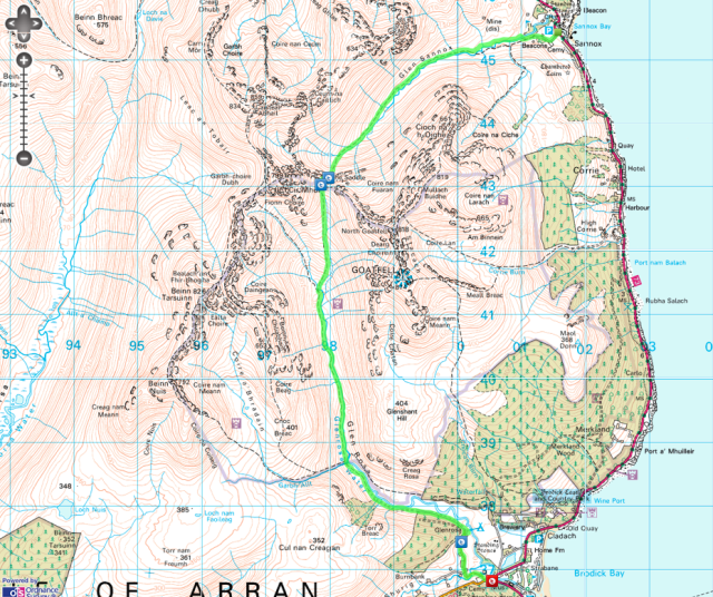
The Route: Goatfell and North Goatfell | Distance: 12.4km | Time: 4 Hrs
Height gain: 954m | Max Altitude: 874m
Start: Brodick Castle Grounds | Finish: Corrie
Map: OS Explorer OL361 | Date: 12/06/2012

Route Map

The clouds finally lifted after a week spent on the island and the high summits where finally revealed for the first time since landing ashore all those days ago. The opportunity had come at last – Summit Day!

I excitedly packed my rucksack before I’d even had time to consume my breakfast. The car door was quickly slammed shut and I drove south towards The Goatfell Range eager for some high adventure in Arran’s highest mountains. Continue reading “Ascent of Goatfell and North Goatfell – Isle of Arran”

The Famous Saddle – Isle of Arran

The Route: Glen Sannox to Glen Rosa via The Saddle
Distance: 15.1km | Time: 4.5 Hrs
Height gain: 635m | Max Altitude: 423m | Start: Sannox Bay | Finish: Brodick
Map: OS Explorer OL361 | Date: 11/06/2012

Route Map

Oh the Saddle, well it’s easy really (well at least on one side anyway)! Well which side, I would ask? Oh the descent side son!

I’d heard this over and over again while on Arran and had become intrigued. The weather had been awful now for two days the low clouds, rain and clag hanging over the mountain like an illness obscuring any hope of a view of their spectacular summits. So it was that I decided rather than attempt a summit bid in the mist and rain I would instead hike along the classic Glen Sannox to Glen Rosa route and climb over the famous Saddle. Continue reading “The Famous Saddle – Isle of Arran”

A hike into the Glens of the Pirnmill Mountains

The Route: Gleann Easan Biorach and Gleann Diomhan | Distance: 18.4km
Time: 5.5 Hours | Height gain: 744m | Max Altitude: 411m | Start: Lochranza Village | Finish: Same as start | Map: OS Explorer OL361 | Date: 07/06/2012

Route Map

‘What’s not to like?’, I asked myself early that morning while sitting in my tent having just decided on my hiking route for the day. It would be a classic glen circuit among the less visited and today very misty Pirnmill Mountains in the north of Arran. We would be visiting Loch na Davie source of the water for Arran Whisky (and the purest natural water source in Scotland). The route would also take me through one of the most remote areas on the island and across a couple of bleak and boggy gaps as well as up and down two magnificent Scottish glens. Continue reading “A hike into the Glens of the Pirnmill Mountains”

Lochranza and the Cock of Arran – Isle of Arran

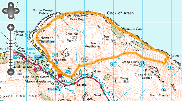
The Route: Lochranza and the Cock of Arran | Distance: 15.4km | Time: 5 Hours | Height gain: 627m | Max Altitude: 267m | Start: Lochranza Village | Finish: Same as start | Map: OS Explorer OL361 | Date: 06/06/2012

Click for Interactive Route Map

We had travelled to the Scottish Isle of Arran to experience something different to add to our inventory of UK hiking, climbing and camping adventures. We hoped for glorious mountains and unspoilt wilderness. Would we find it though?

The trip across the sea by ferry had offered tantalising views of the main mountain ranges to the north of the Island and upon docking we had driven directly north to the isolated and pretty fishing hamlet of Lochranza. Lochranza is a long straggly village that sits beside a charming sea loch. The romantic Lochranza Castle looks out over the sea from a narrow grassy point and I would wager that it would be hard to find anywhere more stereo-typically Scottish looking. Continue reading “Lochranza and the Cock of Arran – Isle of Arran”