The Route: Glen Sannox to Glen Rosa via The Saddle
Distance: 15.1km | Time: 4.5 Hrs
Height gain: 635m | Max Altitude: 423m | Start: Sannox Bay | Finish: Brodick
Map: OS Explorer OL361 | Date: 11/06/2012

Oh the Saddle, well it’s easy really (well at least on one side anyway)! Well which side, I would ask? Oh the descent side son!
I’d heard this over and over again while on Arran and had become intrigued. The weather had been awful now for two days the low clouds, rain and clag hanging over the mountain like an illness obscuring any hope of a view of their spectacular summits. So it was that I decided rather than attempt a summit bid in the mist and rain I would instead hike along the classic Glen Sannox to Glen Rosa route and climb over the famous Saddle.
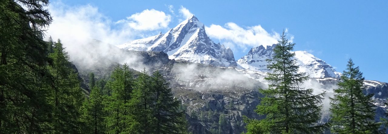
The Saddle is literally as it sounds, a saddle. A saddle strung between the highest mountains on Arran. It dissects the Goatfell Mountain Range in two, North – South. It is the only way to cross between the two enormous glens that dominate the range.

I set off in the usual mist and drizzle that I had become accustomed to over the past week. The pointy peaks that dominate Glen Sannox were all shrouded in mist as usual as I set off giving me no hint of their real height and splendour. Such luminaries as Cioch na h’Oighe, Cir Mhor and Caisteal Abhail were all hidden away behind a thick blanket of grey. The far end of this the most magnificent of Arran’s glens could not be seen at all.
I crossed the small wooden footbridge at the entrance to the glen and started following the Sannox Burn up the valley. Around me it was all wet and boggy underfoot, but the path was firm enough and I began to enjoy the feeling of moving further and further up the valley to its wild and remote head. At the end of the valley I could just glimpse the high mountains towering above in all directions drifting in and out of the circling mist. The landscape had an almost Tolkien-esque and foreboding feel to it.

The lowest gap that I could see up high and ahead must be The Saddle I thought. The path unnervingly started to gain height and wove upwards towards the only chink in this curtain of mountain armour. I climbed more and more steeply upward following it!
As height was gained the rough boulder strewn path gradually swung to the right and I began to enter a steep, sloping and rocky gully, known as the Whin Dyke. The ascent was an awkward hands on scramble requiring much care and concentration.

The rain and mist continued unabated doing their job of making the rock face slippery and slimy as I attempted to negotiate my way up. I was now committed as right on cue the clouds thickened and the rain increased obscuring all but the 10 meters in front of my nose.

It was at this point that I took a wrong turn leading me to become almost cragfast on an exposed buttress of rock. Then as luck would have it I heard voices in the mist. Two climbers were coming down the opposite way to me and by shouting out I could assertion roughly where they were in the gully in relation to myself.
I clambered over to the fellow climbers mightily happy to see someone else out and about in this part of the mountains. We exchanged pleasantries as is customary when in the hills and it turned out that these fellow climbers were in fact Swiss and over in Scotland to sample some hiking and climbing in The Goatfell Range on a kind of busman’s holiday.
I asked the question that was nagging away deep inside me. Did it get worse higher up and which was the right direction? They both assured me it was easy and short and therefore no problem.
No problem, great I’ll press on then. Thinking about it though being told by two Swiss climbers that it is ‘fine’ should have alerted me to the different interpretations of ‘fine’ between a suburban based English guy and two seasoned Swiss Mountain folk! Fine it transpires is indeed a matter of opinion.
I felt distinctly un-fine as I scrambled still further up the ever steepening gully.

Then just like a vision from heaven the col appeared in front of me, yes it was finally The Saddle. At 432m I was finally at the only crossing point of the mountain range. I would have whooped and hollowed but I was so damned relieved to have made it that I just sat down on my backside to reflect on my possible stupidity in attempting such a slippery gully in the first place under such conditions.
Hindsight though is a great thing and in any case I had now reached the Saddle and from now on in it would be all milk and honey back down to Brodick, well in theory. There were granite slabs and outcrops in all directions with slopes rising on either side of the gap looking both steep and rugged. To my west was the formidable Cir Mhor, while to my south-east was North Goatfell.

The descent as it turned out into Glen Rosa was down a remarkably gentle path as promised. A hiked down carefully fording the small burns and negotiating the occasional boulder along the way. Eventually I drifted towards the meandering Glenrosa Water which hugged the valley floor.
Crossing a wide wooden footbridge the glen began to fade behind me as the valley opened up and the first signs of civilisation began to appear ahead of me. I walked on and passed quietly though the tiny Glen Rosa Campsite nestling in the valley, then all of a sudden like a bolt out of the blue I was out of the wilderness and walking along the main road that leads into Brodick town.

People now drove past me in their luxury cars all safe and warm as I trudged along the monotonous tarmac. I wondered to myself how many of them even knew about The Saddle sitting high up in the mountains shrouded in mist and rain as they sped on by below. Even if they did would they be mad enough or bold enough to want to climb over it? Probably not! But the trouble with the mountains is once you get hooked on them they keep drawing you back, I can’t explain it but although I had been wet, a bit scared, covered in mud and wandering about in mist and rain all on my own I would not have swapped the experience for anything on that day or any other day for that matter.
Now having seen the high mountains – if only fleetingly between the clouds mist and rain – I had been left hungry for more. I was already crossing my fingers praying for better weather for tomorrow and bearing in mind it would be my last day on Arran in my head I had already decided I was going to make a bid for the summit of the island’s highest, the mountain of ‘Goatfell‘ now beckoned me like a distant siren
The Highs and the Lows. Altitude Data supplied via socialhiking.org.uk
Find all the Interactive Route Maps from my trip to Arran here:
https://my.viewranger.com/track/details/MTA1OTU1
See more photos from my Isle of Arran Adventure on flickr by clicking on this link: flickr
Next post about Arran coming soon – Ascent of Goatfell!

We, my husband (72) and myself (63) have done this hike the other way round – coming from Glen Rosa three weeks ago – as you can imagine, the descent was highly demanding and left me with terrible muscular pains of both hamstring muscles for almost 4 days. We were enormous relieved when finally reached a “normal” path. But also proud that we managed!
Marie-Claude
LikeLike
Well done the both of you, it is a marvellous hike with a great bit of scrambling!
LikeLike
Thank you for the compliment! Marie-Claude
LikeLike
Pingback: A hike into the Glens of the Pirnmill Mountains – JAMES HANDLON